In the ever-evolving landscape of science and technology, few organizations have shaped India’s trajectory as profoundly as ISRO, the Indian Space Research Organisation. And today, with the launch of the ISRO Geoportal, the nation’s access to satellite data has reached new heights. The platform, through its various applications, has enabled vast potential for industries, governments, and even individuals seeking geospatial data for development, research, and monitoring purposes.
When we speak of satellite data, we usually envision complex missions, massive scientific undertakings, and technological advancements beyond the grasp of ordinary people. However, the ISRO Geoportal has democratized access to this data, making it readily available for the common man. Whether you’re a student, a farmer, a policymaker, or a researcher, the Geoportal ensures that the benefits of satellite technology reach everyone.
ISRO Geoportal: A Gateway to India’s Space Data
The ISRO Geoportal is not just a tool for scientists or space experts—it’s an online platform where anyone can access satellite imagery and geospatial data collected by ISRO’s satellite missions. It is a virtual bridge that connects India’s rich data reserves with the country’s development goals.
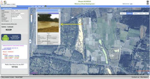
Take, for instance, Bhuvan, one of ISRO’s flagship platforms under the Geoportal. ISRO Geoportal Bhuvan offers an interactive 2D and 3D satellite visualization tool that allows users to access and analyze geospatial data. This platform has proven essential for various government projects, from urban planning to disaster management. People from all walks of life—students, urban planners, and even environmentalists—use Bhuvan to explore and solve real-world problems.
It’s incredible how this single platform has empowered individuals to make data-driven decisions, something that was once reserved for specialized agencies.Urban development in Telangana uses the ISRO Geoportal Telangana platform to identify flood-prone areas, enabling them to prepare more efficient disaster management plans. Before this, they had to rely on inconsistent data from various sources. Now, everything they need is accessible at their fingertips.
Bhuvan, MGNREGA, and Rural Development
Beyond urban development, the ISRO Geoportal has found its way into the heart of rural India, supporting initiatives like MGNREGA (Mahatma Gandhi National Rural Employment Guarantee Act). The collaboration between ISRO Geoportal MGNREGA has changed the face of rural development programs, ensuring transparency, accountability, and efficiency.
Using satellite data from Bhuvan, authorities can track progress in real-time, monitor the status of assets created under MGNREGA, and ensure that the objectives of these programs are being met. This innovation has fostered a deeper trust between the government and its people, knowing that there is now a transparent system in place.
Villages in Maharashtra where MGNREGA projects are running had built water conservation structures. For years, many regions in the state suffered from unpredictable monsoons and water scarcity. Thanks to ISRO Geoportal MGNREGA, the village projects were monitored more effectively, leading to timely completion and tangible improvements in water availability. None of the villagers ever thought that satellite data could change their lives but it did.
ISRO Geoportal and PMAY: A Step Forward in Housing
The impact of the ISRO Geoportal isn’t limited to rural development and disaster management; it extends to urban housing as well. Under the Pradhan Mantri Awas Yojana (PMAY), the ISRO Geoportal PMAY platform helps monitor and manage housing projects, ensuring efficient resource allocation and timely project delivery.
Employees of the housing sector share how using satellite data from ISRO helped their team overcome challenges in land acquisition and project planning. Satellite data provides an overhead view of the land. It helps to make informed decisions about location suitability, environmental impact, and even the best design layouts.
The integration of satellite data into programs like PMAY demonstrates the far-reaching implications of geospatial data for housing and infrastructure development. It has made an essential contribution to achieving the government’s vision of ‘Housing for All,’ ensuring that data-driven decisions shape India’s future housing landscape.
The Impact of ISRO Geoportal in Telangana
While the ISRO Geoportal Telangana platform has been a game-changer for the state, its benefits are being felt across various sectors. In agriculture, for instance, satellite imagery from ISRO aids farmers and policymakers assess crop health, monitor soil conditions, and optimize water usage. These insights ensure higher productivity and better management of resources.
Farmers from Telangana are able to save their crops from drought by using satellite imagery. They used to rely on traditional farming methods, which often left us vulnerable to natural changes. But now, with access to ISRO data, they know when to plant, when to irrigate, and how to make the most of their resources.
This story is echoed by countless farmers across the country, as they harness the power of satellite data to enhance agricultural practices. With platforms like the ISRO Geoportal, the agricultural sector has seen a technological revolution, empowering farmers with critical information at just the right time.
SP Kosta and Aryabhata: The Pioneers Behind India’s Satellite Program
Behind ISRO’s numerous achievements lies the legacy of pioneers like Shiv Prasad Kosta, the Deputy Director of the Aryabhata project, India’s first satellite. Born in Madhya Pradesh, Kosta’s career was a testament to his unwavering belief in the power of science to propel India into a new age of technological advancement.
Kosta played a critical role in the Aryabhata mission, working alongside some of the brightest minds in Indian science, including Dr. Vikram Sarabhai and Dr. APJ Abdul Kalam. Aryabhata, launched in 1975, was not just a satellite; it symbolized India’s entry into the competitive global space race.
The satellite’s success was a turning point for ISRO, laying the groundwork for the development of future missions. Kosta’s contribution to Aryabhata paved the way for the satellites we rely on today for weather forecasting, communication, and, most importantly, geospatial data access through platforms like ISRO Geoportal.

Biography of Shiv Prasad Kosta
ISRO Geospatial Data: Mapping India’s Future
Today, the demand for ISRO Geospatial Data is growing rapidly, as more industries discover the benefits of satellite imagery. Whether it’s for environmental conservation, urban planning, or disaster management, geospatial data has become a critical resource for driving informed decision-making.
Platforms like ISRO Geoportal provide users with access to high-resolution images that can be used to monitor forest cover, track the effects of climate change, and even plan smarter cities. The geospatial data from ISRO is helping map India’s future, ensuring that we grow sustainably while addressing key challenges like resource management and disaster mitigation.
One of the most significant aspects of this data is its availability to everyone, from government bodies to private companies, researchers, and students. No longer is satellite data confined to the elite few; it’s a resource that has been democratized, available to anyone with an internet connection.
The Importance of ISRO Locations and Launch Pad Locations
To truly appreciate the marvels of India’s space program, one must understand the strategic importance of ISRO locations and ISRO launch pad locations. The space agency’s launch pad in Sriharikota, Andhra Pradesh, has been the site of numerous landmark launches, including those of Aryabhata and the Mars Orbiter Mission (Mangalyaan).
These locations serve as the heart of India’s space endeavors, and each mission launched from these pads has contributed to ISRO’s growing legacy. It’s here that the nation’s scientists and engineers work tirelessly, pushing the boundaries of space exploration, all the while ensuring that the fruits of their labor, like the data from the ISRO Geoportal, benefit the entire nation.
A Future Empowered by ISRO Geoportal
As India progresses toward becoming a global technology leader, the ISRO Geoportal continues to play an essential role in this journey. By providing open access to satellite data, ISRO has enabled individuals, industries, and governments to make informed decisions, tackle pressing issues, and pave the way for sustainable development.
It’s amazing to see how technology has become an integral part of daily life in India. From MGNREGA projects in rural areas to urban planning in Telangana, ISRO Geoportal has truly revolutionized the way we use satellite data. It’s a tool for everyone—students, policymakers, farmers, scientists—each harnessing the power of space to improve the quality of life here on Earth.
In the words of one of India’s great visionaries, Dr. APJ Abdul Kalam, “Dreams are not those which come while we are sleeping, but dreams are those when you don’t sleep before fulfilling them.” Thanks to platforms like ISRO Geoportal, the dream of using satellite data to solve real-world problems is no longer a distant dream—it’s a reality that’s unfolding before our eyes.
Leave a Reply